


http://www.watch-documentaries-online.com/wp-content/uploads/2010/04/man_on_wire.jpg
Man on Wire is a 2008 British documentary film directed by James Marsh. The film chronicles Philippe Petit's 1974 high-wire walk between the Twin Towers of New York's World Trade Center. It is based on Philippe Petit's book, To Reach the Clouds, recently released in paperback with the new title Man on Wire. The title of the movie is taken from the police report that led to the arrest (and later release) of Petit, whose performance had lasted for almost one hour. The film is crafted like a heist film, presenting rare footage of the preparations for the event and still photographs of the walk, alongside reenactments (with Paul McGill as the young Petit) and present-day interviews with the participants.
http://en.wikipedia.org/wiki/Man_on_Wire

http://www.twolia.com/blogs/heres-looking-like-you-kid/files/2009/09/vertigo_poster.jpg
Vertigo is a 1958 American psychological thriller film, directed by Alfred Hitchcock and starring James Stewart, Kim Novak, and Barbara Bel Geddes. The film was written by Alec Coppel and Samuel A. Taylor, based on a novel by Boileau-Narcejac. A retired police detective, who has acrophobia, is hired as a private investigator to follow the wife of an acquaintance to uncover the mystery of her peculiar behavior.


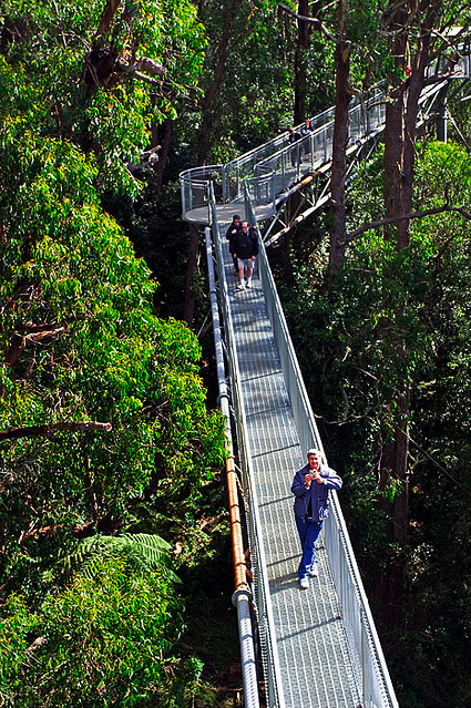
The Southern Ridges (Chinese: 南部山脊) is a 9-kilometre (5.6 mi) trail that connects parks along the southern ridge of Singapore. Some of the attractions along this trial include its greenery and the connecting bridges. This project linked up the parks between the West Coast Park and HarbourFront. The idea to link these parks were coined in 2002 by Urban Redevelopment Authority (URA) and it took 2 years to complete and cost S$25.5 million.
http://en.wikipedia.org/wiki/Southern_Ridges
http://patokallio.name/photo/travel/Singapore/SouthernRidges/HendersonWaves_Waves.JPG
http://photos2.meetupstatic.com/photos/event/4/7/3/3/highres_7818227.jpeg


The Blackpool Tower is a tourist attraction in Blackpool, Lancashire in England which was opened to the public on 14 May 1894. Inspired by the Eiffel Tower in Paris, it rises to 158m. The Tower is a member of the World Federation of Great Towers.The tower can be seen from most places within a 30-mile (48 km) radius including Barrow-in-Furness, Lancaster, Liverpool, Manchester, Preston and Southpor. It is a Grade 1 listed building.
Construction
The idea for the tower came when Blackpool Mayor John Bickerstaffe commissioned the design of a new landmark for the town after he visited the Great Paris Exhibition in 1889 and was impressed by the Eiffel Tower. When he returned to Blackpool he set up a committee of businessmen in order to raise the funds to build a similar design in the town.
He invested £2,000 of his own money to form, with other local investors, the Blackpool Tower Company Limited, registered on 19 February 1891.
Two Lancashire architects, James Maxwell and Charles Tuke, designed the Tower and oversaw the laying of its foundation stone, on 29 September 1891 with a time capsule buried beneath it. By the date the Tower finally opened on 14 May 1894, both men had died. The total cost for the design and construction of the tower and buildings was about £290,000. Five million bricks, 2,500 tonnes of iron and 93 tonnes of cast steel were used to construct the tower. The cast steel and iron are distributed in such a way that if it did ever collapse it would fall into the sea.
Unlike the Eiffel Tower, Blackpool Tower is not free-standing. Its base is hidden by the building which houses Blackpool Tower Circus. The building occupies a total of 5,050 sq metres (6,040 sq yards). At the summit of the tower there is a flagpole.
http://en.wikipedia.org/wiki/Blackpool_Tower
http://www.freefoto.com/images/37/01/37_01_54---Blackpool-Tower_web.jpg?&k=Blackpool+Tower


Willis Tower is strategically located on Wacker Drive in the heart of the West Loop, Chicago’s premier submarket and home to its largest corporations and commuter rail stations. Completed in early 1973, Willis Tower is an attractive and contemporary 110-story trophy office tower consisting of steel columns and beams in a “mega-module” system. The building contains approximately 3.8 million rentable square feet (“RSF”) including approximately 159,000 RSF of retail space. The Property also features a 160-car executive parking garage accessible from Franklin Street. Other amenities include a world-class broadcast platform, tallest skydeck, full-service conference center, fitness facility, and exceptional technology features.
Completed May 3, 1973, Willis Tower rises to a height to 1,450 feet and is one of the most recognizable landmarks in the Chicago skyline and in the world. The building held the record for the world’s tallest building for 25 years until the Petronas Towers in Kuala Lampur, Malaysia were built in 1998.
In 1982, the antennas added to the building increased its total height to 1,704 feet. In 2000, one of the building’s antennas was extended to 1,729 feet, making it the world’s tallest building to the tip of its antenna. The building held this title until early 2009 when Burj Dubai topped out at over 2,600 feet, making it the tallest man-made structure ever built.
Designed by the architectural firm Skidmore, Owings & Merrill for Sears, Roebuck & Company, the world’s largest retailer at the time, the 3.8 million RSF building is the preeminent office address in Chicago and one of the premier properties in the world. The Willis Tower provides an exceptional West Loop location, unparalleled views from all of the property’s highly efficient floors and unmatched prestige.
http://www.willistower.com/propertyprofile.html
http://www.realestatechannel.com/news-assets/willis-tower-chicago.jpg
http://www.home-designing.com/wp-content/uploads/2009/07/sears-tower-chicago.jpg
http://www.home-designing.com/wp-content/uploads/2009/07/willis-tower-chicago.jpg

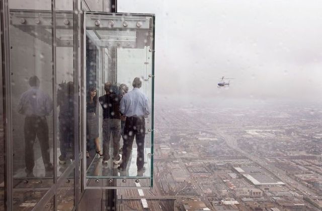
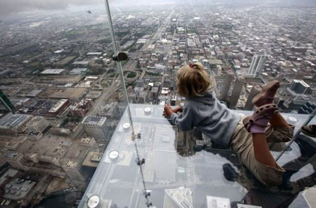
Glass Floor
The Facts:
Thickness: 2 ½ "
Size of each panel: 42" by 50"
Layers from the top down:
■ 3/16 " scuff plate (replaced annually)
■ Two ½ " layers of clear tempered glass, laminated together
■ A one inch layer of air (for insulation)
■ Two ¼ " layers of clear tempered glass, laminated together
Load tests are performed annually on each panel to ensure safety
TEST YOUR NERVE!
With a view 1,122' straight down, even those not afraid of heights
might need a little help. Think you can handle it? Wait till you get
here and see if you feel the same way.
The Glass Floor has been specifically designed for you to have fun
on it, so walk or crawl across it, sit on it or even jump on it.
Don't worry it won't break.
The floor is 256 square feet of solid glass that is five times stronger
than the required weight bearing standard for commercial floors. It can
actually withstand the weight of 14 large hippos.
Also on this level, be sure to check out the Outdoor Observation Level.
Feel the breeze at 342m (1,122') above the ground.
http://www.cntower.ca/plan_your_visit/attractions/glass_floor/

Landscape Promontory is a high scenery platform designed by Paolo Burgi as a part of Cardada project, a revitalization of the mountain Cardada that expected to be completed in 2010. The corridor is made of iron and titanium leads to a platform overlooking the scene Lago Maggiore. Not only the sights that can be enjoyed by visitors. The symbols in the tile and the written description information on the platform railing to offer references and literary history.
http://www.europetraveldestinations.com/amazing-scenery-in-landscape-promontory-switzerland.html
http://webecoist.com/2009/09/14/12-insane-elevated-eco-parks-dizzying-outdoor-overlooks/http://image57.webshots.com/157/4/83/96/2419483960088133698KJRXRt_ph.jpg


http://www.archdaily.com/7816/aurland-look-out-saunders-arkitektur-wilhelmsen-arkitektur/31068-c1-model-1/
http://www.nzwood.co.nz/images/uploads/Aurland%20Lookout%202.jpg
The site is above Aurland, a small town in Sogn og Fjordane, one of the larger fjords on the West Coast of Norway. Aurland is three hours drive from Bergen, Norway’s second largest city. We were one of three architecture firms invited to deliver a design proposal for this site. After winning we worked on detail drawings for the project together with Node Engineers, Bergen. The project was
built in Fall 2005 and was officially opened in June 2006.
The place has attracted people from all over the world. We called our competition entry «640m over Aurland and 20120 km from Tokyo», keeping in mind the uniqueness of the place in the bigger picture.
Nature first and architecture second was the guiding principal when we sat down to design this project. It was immediately obvious to us that in such beautiful surroundings one must make the least possible encroachment in the existing landscape and terrain. The landscape is so fantastic that it is difficult to improve the place, but at the same time very easy to destroy the atmosphere by inserting too many elements into the site. Even though we have chosen an expressive form, the concept is a form of minimalism, in an attempt to conserve and complement the existing nature.
Today there are many people stopping at this site to enjoy the phenomenal views over the fjords. At times the areas gets filled with cars and tour busses. One of the first things we decided to do was to form a small parking area for 2 buses and 10 cars further up the road to help keep the place pure and not to disturb the look out. The construction is a bridge that one can go out onto, as a structure in the air. The structure is 4 m wide, 30 long, and 9m high out at the very end.
To make the situation even more dramatic it was important for us to create the experience of leaving the mountainside. We wanted people to come out in the air. The construction creates a distinct horizon; a bridge in the open room of this large fjord. It is imperative that the landscape and the vegetation not altered, but are protected so that one came come out from the landscape and experience it from new standpoint.
We have managed to behold all of the large pine trees on the site. This allows us to create an interaction between the structure and nature. One can walk out into the air through the treetops, helping dramatise the experience of nature and the larger landscape room.
http://www.archdaily.com/7816/aurland-look-out-saunders-arkitektur-wilhelmsen-arkitektur/ntower.ca/

http://www.grandcanyonskywalk.com/gallery.html
http://www.grandcanyonskywalk.com/
Go where the eagles dare to fly … welcome to the Grand Canyon Skywalk. Carved by the Colorado River over 15 million years and spanning approximately 277 miles long; the Grand Canyon captures the hearts of visitors around the world with its epic views of majestic mountain peaks and valleys, clear skies that soar into deep shades of blue, and the awesome biological diversity of Mother Nature. Located at the canyon’s west rim, the Grand Canyon Skywalk allows visitors to “Walk the Sky” with its unique glass bottomed cantilever U shaped observation deck that spans 70 feet (21.34 meters) over the canyon’s rim and sits 4,000 feet (1,219 meters) above the Colorado River. A construction masterpiece, the glass – which is the only element that separates visitors from the deep canyon floor – weighs 1.2 million pounds. Completed in March 2007, the Skywalk is located on the Hualapai Indian Reservation in northwest Arizona and is the only architectural wonder of its kind that allows visitors to truly take in the experience of this beautiful and majestic place.

http://www.goldenerochs.at/images/top/five_fingers.jpg
5 Fingers is a free viewing platform on the Krippenstein that was named "5 Fingers" by virtue of its hand-like hand shape.
It is called the "most spectacular viewing platform in the Alps" because the individual, approximately 4 meters long fingers were built over a precipice of about 400 m (1200 ft) depth.
The "fingers" are about 12 feet long and were built over a chasm of about 400 m (1200 ft) depth. The viewing platform can be reached through a walk of less than 20 minutes from the Krippenstein station of the Dachstein cable car line.
At the first finger (from left to right) a metal frame was assembled, so visitors can take a framed photo of themselves as a souvenir.
The second finger was equipped with a glass bottom which allows to look down into the abyss below.
The third finger is shorter than all others and is not accessible all the way. It has a kind of springboard and symbolizes the freedom of the mountains.
The fourth finger has a hole in the floor that allows a free view into the abyss.
At the fifth finger a telescope is available free of charge.
The observation deck is illuminated at night until midnight and can therefore be easily seen with the bare eye as far as the towns of Hallstatt and Obertraun.
The Treetop Walk is a unique attraction which enables visitors to experience a 1500 metre walk through beautiful warm temperate rainforest.
The uniqueness of our attraction in comparison to other rainforest walks is that 500 metres of this walk is nestled in the treetop canopy some 20-30 metres above ground level.
The walkway culminates in Knights Tower, a spiral tower that rises to a breathtaking 45 metres above the forest floor.
Then there’s the thrills and challenges of two confronting swaying springboard cantilevers suspended 25 metres above the forest floor which take guests to the edge of the escarpment.
The roller coaster hesitates for a split second at the peak of its steep track after a long, slow climb. You know what's about to happen — and there's no way to avoid it now. It's time to hang onto the handrail, palms sweating, heart racing, and brace yourself for the wild ride down.
http://kidshealth.org/teen/your_mind/mental_health/phobias.html


Steel roller coasters
Wooden roller coasters
Steel coasters are known for their smooth ride and often convoluted shapes that frequently turn riders upside-down via inversions. Wooden coasters are typically renowned by enthusiasts for their rougher ride and "air time" produced by negative G-forces when the train reaches the top of hills along the ride. There are also hybrid roller coasters that combine a steel structure with wood tracks, or a wood structure with steel tracks.
Modern roller coasters take on many different forms. Some designs take their cue from how the rider is positioned to experience the ride. Traditionally, riders sit facing forward in the coaster car, while newer coaster designs have ignored this tradition in the quest for building more exciting, unique ride experiences. Variations such as the stand-up roller coaster and the flying roller coaster position the rider in different ways to provide different experiences. Stand-up coasters involve cars that have the riders in a standing position (though still heavily strapped in). Flying coasters have the riders hanging below the track face-down with their chests and feet strapped in. Vekoma "Flying Dutchman" coasters have the riders starting out sitting above the track, then they fully recline so that the riders are looking at the sky. Eventually, they twist into the "flying" position. B&M flying coasters have the riders hanging below the track like in an inverted (hanging) coaster. To go into the flight position, the section of the car where the riders' feet are raised to the track. That way, they start in the flight position. In addition to changing rider viewpoint, some roller coaster designs also focus on track styles to make the ride fresh and different from other coasters.


"The area occupied by the exhibition site had been marshy land and only developed after the Second World War. This redevelopment comprised three major impacts-improvements to Waterloo railway station, a new Waterloo Bridge and the construction of the LCC County Hall-creating a triangle into which the South Bank Exhibition was slotted.
The Dome of Discovery and the Skylon were two notable attractions, but the one building to remain is the Royal Festival Hall.
The earliest photograph taken in 1958, shows the river frontage between the Royal Festival Hall on the left and the County Hall on the right. The huge gap between these two buildings was the site of the Southbank Exhibition. This gap came to be filled by the Shell Building and other offices. It was completed by 1963 and was one of the first tall office blocks to be built in London with a height of 350ft.
The London Eye is much higher than the Shell Building and, at 450 feet tall, it was the third highest structure in London when it was opened.
The Shot Tower, 120 ft tall, had been a London landmark since its construction in 1826. Its purpose was the production of shot from lead.


